

The Chagos Archipelago, also known as the Chagos Islands, is one of the most remote and strategically important island groups in the world. Located in the central Indian Ocean, this chain of tropical atolls has gained global attention due to its unique geography, rich marine biodiversity, and complex political history. Despite being largely uninhabited today, the Chagos Archipelago plays a critical role in international relations, environmental conservation, and regional geopolitics.
This article explores the Chagos Islands, covering their location, history, ecological importance, and ongoing sovereignty debates.
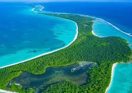
Where Is the Chagos Archipelago Located?
The Chagos Archipelago lies in the central Indian Ocean, roughly midway between Africa and Indonesia. It is situated south of the Maldives and north-east of Mauritius. The archipelago consists of more than 60 low-lying islands and atolls, spread across approximately 640,000 square kilometers of ocean.
The largest and most well-known atoll in the Chagos Islands is Diego Garcia, which hosts a major military base. The islands are surrounded by pristine coral reefs and deep ocean waters, making them an ecologically significant marine region.
Overview of the Chagos Islands
The Chagos Archipelago is made up of five main atoll groups:
· Diego Garcia
· Peros Banhos
· Salomon Islands
· Three Brothers
· Egmont Islands
Most of the Chagos Islands are uninhabited, with no permanent civilian population. The islands are characterized by flat terrain, white sandy beaches, coconut palms, and extensive coral reef systems.
A Brief History of the Chagos Archipelago
The history of the Chagos Archipelago is closely tied to colonial expansion and global power politics. The islands were first discovered by European explorers in the 16th century and were later claimed by France. In the 19th century, control passed to the British, and the islands became part of the British Empire.
For much of their early history, the Chagos Islands were used for coconut plantations, with a small population of indigenous Chagossians, also known as Ilois, living and working on the islands.
Displacement of the Chagossian People
One of the most controversial aspects of the Chagos Archipelago’s history is the forced removal of its native population. Between the late 1960s and early 1970s, the Chagossians were displaced to make way for a military base on Diego Garcia.
Thousands of islanders were relocated to Mauritius and the Seychelles, where many faced poverty and social hardship. The displacement remains a major human rights issue and has led to decades of legal challenges and international debate.
Political and Legal Status of the Chagos Islands
The Chagos Archipelago is currently administered by the United Kingdom as the British Indian Ocean Territory (BIOT). However, Mauritius claims sovereignty over the Chagos Islands, arguing that the archipelago was unlawfully separated from its territory before Mauritian independence.
In recent years, international bodies, including the United Nations, have weighed in on the dispute. Several rulings and resolutions have supported Mauritius’s claim, calling for the return of the Chagos Archipelago to Mauritian control.
Despite these developments, the United Kingdom continues to administer the territory, and the issue remains unresolved.
Strategic Importance of the Chagos Archipelago
The Chagos Islands hold immense strategic value due to their location in the Indian Ocean. Diego Garcia, the largest island in the archipelago, hosts a major military facility used primarily by the United States and the United Kingdom.
This base plays a crucial role in global military operations, surveillance, and logistics across the Middle East, Africa, and Asia. The strategic significance of the Chagos Archipelago is one of the key reasons behind the ongoing geopolitical tensions surrounding the islands.
Environmental and Marine Significance
Beyond politics, the Chagos Archipelago is one of the most environmentally important regions on the planet. The islands are surrounded by some of the healthiest coral reef ecosystems in the world.
The Chagos Islands Marine Protected Area, established in 2010, covers over 640,000 square kilometers, making it one of the largest marine protected areas globally. It provides sanctuary for:
· Over 1,000 species of fish
· Numerous coral species
· Sea turtles
· Sharks and rays
· Migratory seabirds
Because human activity is extremely limited, the Chagos Archipelago serves as a natural laboratory for studying pristine marine ecosystems and climate change impacts.
Can People Visit the Chagos Islands?
Access to the Chagos Archipelago is highly restricted. Tourism is not permitted, and entry generally requires special authorization from the British authorities. Most visitors are scientists, conservationists, or military personnel.
The lack of tourism has helped preserve the natural environment of the Chagos Islands, but it also limits economic opportunities for displaced Chagossians who seek the right to return.
The Future of the Chagos Archipelago
The future of the Chagos Islands remains uncertain. Ongoing legal battles, diplomatic negotiations, and international pressure may eventually reshape the governance of the archipelago. At the same time, climate change poses a serious threat, as the islands are low-lying and vulnerable to rising sea levels.
Balancing environmental conservation, strategic interests, and human rights will be critical in determining the long-term fate of the Chagos Archipelago.
Conclusion
The Chagos Archipelago is far more than a remote chain of tropical islands. The Chagos Islands represent a crossroads of history, geopolitics, environmental science, and human rights. From their pristine coral reefs to their contested political status, the archipelago continues to draw global attention.
Understanding the Chagos Archipelago is essential for appreciating the broader challenges facing island territories in a changing world—where strategic interests, environmental preservation, and justice for displaced communities must coexist.